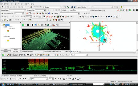
LP360 for ArcGIS™ is a first-of-its-kind LIDAR software extension for the ESRI™ ArcGIS environment. The LP360 LIDAR extension uses a specially-designed ArcMap™ data layer to access points directly from industry standard LAS files. LP360 completely integrates LIDAR point cloud datasets into ArcGIS without requiring an import or conversion process. With LP360 LIDAR data can be combined with data in any format supported by ArcGIS.
LP360 for ArcGIS is easy to operate and makes using LIDAR data in ArcGIS easy. LP360 for ArcGIS is incredibly fast, not RAM sensitive, and includes a large suite of innovative tools. LP360 for ArcGIS is the easiest, fastest, and most powerful way for GIS professionals to use LIDAR in ArcGIS.
LP360 for ArcGIS includes a powerful Point Cloud Task framework. The Point Cloud Task framework is a user friendly interface for generating point cloud statistics and previewing basic classification filters, height from surface filters, height filters, building point classification, building outlines, and macro filter stacks.

ArcGIS extension with geospatial analysis capabilities for mlitary applications.

It is a plug-in that provides interoperability between AutoCAD and ArcGIS.


Comments